Τα Maps .... πάνε πόλεμο!
Η τεχνολογία στην υπηρεσία του πολέμου, ή πως να ανταλλάσετε στοιχεία και δεδομένα για να βρίσκετε περιπολίες, συμβάντα του πολέμου και αντίστοιχο υλικό που είναι χρήσιμο μόνο σε όσους ζουν τη ... συγκεκριμένη κόλαση [λέγε με ΙΡΑΚ]. Ή έχουν σοβαρό εγκεφαλικό πρόβλημα.
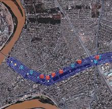
The new technology--called the Tactical Ground Reporting System, or TIGR--is a map-centric application that junior officers (the young sergeants and lieutenants who command patrols) can study before going on patrol and add to upon returning.
Baghdad route planner: A new map-based application allows patrol leaders in Iraq to learn about city landmarks and past events and enter new data. In this mock-up provided by DARPA (the map does not reflect actual events), the purple line shows a possible Baghdad patrol route. Past events in a 300-meter buffer are noted. Hostile actions, such as IED attacks or shootings, appear as various red icons; friendly actions, such as visits to schools, appear as blue icons. Clicking the icons brings up text, photos, even videos. Credit: Courtesy of DARPA [U.S. Defense Advanced Research Projects Agency][Via]


0 Comments
Post a Comment